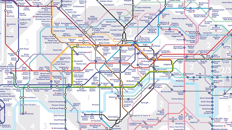
View and download the official London Tube map on this page.
The iconic London Underground is one of the quickest and most efficient ways to get around the capital. Spanning 11 lines and connecting 270 stations, the Tube serves as the lifeblood of the city, effortlessly linking you to world-famous attractions, museums, theatres, shopping districts and hidden gems.
Start your journey with confidence—plan ahead, travel smart, and enjoy London like a local.

Download the official London Tube map
Download the London Tube map [PDF 839 KB].
Additional maps
Discover more handy London maps for your journey or stay in London.
How to use the London Tube map?
The London Tube map is divided into nine zones, with 11 lines connecting 272 stations.
Zone 1 in the middle of the map is located in central London, while zones six to nine are on the outskirts of the city. Different charges apply within these zones and how you move between them.
The 11 London Underground lines are represented by different colours and many stations serve multiple lines.
Interchange stations are marked on the map with a round symbol. This means you can easily change lines at these stations either on the same track, within the same station, or just a short walk to another station of the same name.
Some interchanges require passengers to tap their Oyster or contactless payment method to help the system follow your journey and calculate the correct fare.
You can find out more information about the Tube with the tourist guide to the London Underground.
Use the TfL Journey Planner to find out more about the best routes, travel times and prices.
Other helpful guides for the London Tube
- Learn all about how to use the Tube.
- Explore more free London travel maps.
- Discover the Visitor Oyster Card and travelcards in London.


